

Applications of the CASiMiR Model
Floodplain Vegetation Simulation
Casimir vegetation model was originally developed at the Center for Ecohydraulics Research (CER), University of Idaho, Idaho, USA. The ecological and numerical processes of the model were conceptualized, coded and verified as a part of Dr. Rohan Benjankar’s dissertation (Benjankar, 2009). Later, the concept was coded (Finalized) in GIS platform as a component of Emilio Politti’s master thesis (Politti, 2008). The project was sponsored by Kootenai Tribe of Idaho (KTOI) and funded by Bonneville Power Administration (BPA). As a development process, the model is re-coded into Microsoft. Net using C# by Dr. Gregory Egger and Emilio Politti at the Environmental Consulting GmbH, Klagenfurt, Austria.
Floodplain vegetation and physical habitat are mutually interdependent; alterations to the Natural flow regime yield effects on the vegetation spatial, quantitative and qualitative distribution. Upon a certain extent, riparian vegetation is therefore a mirror of the ecosystem processes which have undergone in the floodplain. Such processes effects are often measurable over a long time scale which goes beyond the regular human observation possibilities. Nevertheless, it is often required, either for management or research purposes, to know what will be the consequences of habitat alterations.
Casimir Vegetation is designed to meet this need since it incorporates the main key factors and behavior of riparian ecosystems. Key factors include the essential riparian ecosystem driving forces while behavior includes vegetation responses to such factors, which are generally found in temperate and Alpine climates.
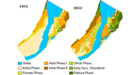
The model concept assumes that vegetation development depends by the functional relationship between hydrology, physical processes and vegetation communities. In the model conceptualization, physical processes are represented by height over mean water, shear stress (as indicator of morphodynamic disturbance) and flood duration. These factors allow the successful establishment and development of the vegetation or its retrogression to the initial stage.
Casimir Vegetation main feature is the vegetation succession or retrogression in space and time and it is further divided in modules, namely: recruitment, morphodynamic disturbance and flood duration. The model is addressed as dynamic because it takes different inputs for each simulated year and because the outputs of each model run is fed again to the model as input for the next iteration. The simulations results are in form of maps, and tables to ease the visualization and processing of the simulated scenarios as well as the dissemination and reporting of the findings.