

Applications of the CASiMiR Model
Fish Habitat Simulation 1D / 2D
The use of fish as an indicator species has several advantages over the use of other benthic organisms (SCHMUTZ et al. 1995). This is primarily due to the fact that fish have been a source of food, and in many cases, have provided an economic benefit to the surrounding human population. For these reasons, damage to fish populations due to pollution or the construction of barriers have been well-documented and considered seriously, whereas the vast majority of aquatic species have only more recently been studied. The main advantages of using fish as the indicator species can be summarized as:
- The total number of fresh water fish species is low as compared to other species (for example, Macrozoobenthos) and are relatively easy to recognize. Additionally for many fish species, there exists a strong dependence between the structural and hydraulic properties of a river, and the habitat requirements during each life stage.
- Due to the migration behavior of many species, fish provide additional information regarding the lateral and longitudinal connectivity, as well as the passibility of a river.
- Habitat requirements are often well-documented for those species which have had a particular interest to fisheries experts and reseachers
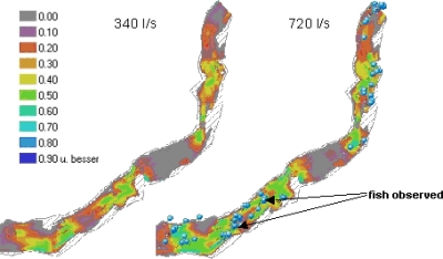
The above parameters are also the main model input parameters in CASiMiR-Fish and make up the largest portion of a fuzzy-logic approach which integrates the existing, but often not precise knowledge of fish habitat requirements. Additional classified parameters such as water temperature, pool sizes, and cover types can also be taken into account. The hydraulic habitat parameters of water depth and flow velocity are included in the base version using a simple approach, where the water depth and energy slope are determined. Required input data for the basis version are measured or calculated water surface elevations. An expanded version of CASiMiR allows for the use of 2D hydraulic calculations (eg. from HYDRO_AS-2D) to be inlcuded as well. Currently under development is a GIS-based Meso CASiMiR model which allows for an unlimited number of user-defined input parameters.